What is Multi-Band GPS?
Multi-band GPS systems offer much more reliable and consistent locating and positioning for autonomous systems and multi-frequency devices. These new technologies are designed to reduce location errors and to provide outstanding accuracy for even the smallest devices. Additionally, they enable devices to get up and going significantly quicker due to the faster “fix” times a multi-band GPS system affords. Understanding and taking advantage of the benefits of multi-band GPS can ensure the most accurate positioning for your multi-frequency applications.
The Basics of GPS and GNSS
Most of us are familiar with global positioning systems, also known as GPS. These systems are included in most smartphones and offer navigation assistance for drivers in the United States and around the world. Most GPS systems use a single connection to the satellites that circle the earth and provide positioning information for GPS applications.
GPS was developed by the United States in 1978. This system operates in the L1 L2 band, which is the part of the radio signal spectrum that transmits and receives between 1 and 2 gigahertz. GPS is considered to be the most accurate and reliable navigation system in the world. Because it operates in the L1 L2 band, it is not as affected by delays and minimizes weather effects on the signal it produces. GPS satellites use rubidium clocks that are extremely accurate and are synchronized with cesium clocks on the surface of the Earth.
In recent years, other countries and companies have put their own satellites and systems in place. Each of these systems, including U.S. GPS systems, are referred to as constellations:
- GLONASS is Russia’s global positioning system. There are currently five versions of GLONASS, including one still in development. GLONASS is used for smartphones and other devices. It is not as accurate as GPS.
- BeiDou consists of two separate constellations, BeiDou-1 and BeiDou-2, with Bei-Dou-3 expected in the near future. China began building the third generation of BeiDou in 2015. It will provide global functionality, in contrast to the previous two generations.
- QZSS is the Japanese entry in the global positioning industry. It is compatible with GPS and uses both the traditional rubidium clock timekeeping and an experimental crystal clock synchronization system that is still under development.
- Galileo was developed by the European Union to be compatible with both GPS and GLONASS.
Each of these constellations has been developed to provide redundancy and to ensure continual availability for end-users.
Components of GPS Systems
GPS systems consist of three basic components:
- The satellites are designed to provide a constant flow of location information on their own positioning in the sky.
- Ground stations receive data from the satellites and use radar to determine the precise point positioning, or PPP, of each satellite that interacts with the specific ground station.
- The mobile user link, or MUL, is the receiver that takes the information from the satellites and the ground stations and calculates the exact position of the end-user. The MUL may be the GPS system in a smartphone, in a vehicle or in an autonomous robotic system.
What Are Multi-GNSS Systems?
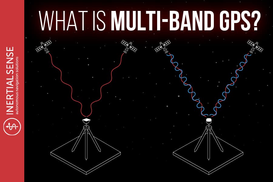
While traditional GPS systems can access multiple constellations, traditional GPS is designed to use just one set of frequencies to provide location services. This means that traditional GPS systems can usually only access a single frequency or band from each of the constellations. However, multi-GNSS systems can access more than one range of frequencies from a single constellation or different constellations. These systems are also referred to as multi-band GPS systems and can provide much greater stability and improved accuracy for both standard and autonomous navigation. A multi-frequency solution is useful in this case.
Understanding the Benefits of Multi-Band GPS
If you think of a single-band GPS as a single connecting line to the communications and geolocation network, dual-band and multi-band connections are added lines that can replace a broken connection or line with another that will provide connectivity as needed. These multi-frequency solutions are ideally suited for use in critical applications that require continuous connectivity to determine precise locations without interruptions as well as fast “fix” time to obtain GPS activity. One such area is autonomous groundskeeping devices like larger commercial mowers that need to follow precise paths on the ground and be able to keep or regain their GPS fix quickly. These will have a direct line of sight to GPS satellites the majority of the time as they work in larger fields and open landscapes, but will occasionally operate under a tree, bridge, or other structures that can hinder this signal. Having a multi-frequency GPS connection helps the mower to stay locked into its position. If it passes through a structure that blocks all GPS, these multiple bands allow for it to connect within seconds of leaving the covering. GPS accuracy can be significantly helped by RTK technology as well.
About RTK and Fix Times
Global positioning systems typically use real-time kinematic or RTK processes to enhance the quality of information derived from ground stations and from satellites. This technology has enabled precise, centimeter-level accuracy for GPS positioning. It works by utilizing a ground-based, fixed, and pre-surveyed sensor to send corrections to the INS system, a bit like setting your hand on something stable to get your bearings after spinning around a few turns. As is mentioned above, an issue with RTK is the “fix” time a single band RTK system takes. This means the device will need to wait for 1, 2, or even 5+ minutes sometimes for the device to catch enough signal from the GPS constellation in order to have enough usable data to start the vehicle. That’s far too long for many people and applications. The single-band receiver can only detect information on the L1 frequency which significantly limits the speed these devices can get a fix on the precise location and may affect the accuracy of the information. By contrast, multi-GNSS systems can process several different frequency bands, which can reduce RTK initialization and fix solutions to a considerable degree. Our devices tend to gain fix within seconds of turning the device on. This is a game-changer for many applications. Need a drone to launch quickly to respond to a threat? You’ll need dual-band GPS INS. Have a device that continually loses GPS because of its environment? You’ll need a dual-band GPS INS. Altogether, PPP is much faster and easier with multi-band GPS systems that can rely on more than one frequency and can access both the L1 and L2 band.
Cost of Multi-GNSS Systems
Until fairly recently, multi-GNSS and multiband systems were priced out of reach for most smaller developers of devices that use geolocation. Dual-band and multi-frequency technologies typically cost $5,000 or more and were reserved for high-end applications in aerospace and other industries. Today, however, the cost of dual-band systems is much more affordable, which can make PPP a practical option for smaller devices and developers for the consumer, commercial, and even student marketplaces.
Applications for Multi-Band GPS
Devices that are used to determine precise geolocation are often used in the robotics and autonomous systems environment. They can be necessary for transportation and mapping where fix time and accuracy matter. Positioning systems that use multi-band GNSS offer superior reliability for a wide range of applications and reduce errors that can arise from systems that operate only on the L1 or L2 band.
Reliable Solutions from Inertial Sense
At Inertial Sense, we offer practical and cost-effective solutions for all your multi-frequency and multiband GNSS requirements. Our attitude-heading reference systems combine compact sizes with affordable pricing to make your autonomous positioning systems as functional as possible. Inertial Sense offers single and dual-compassing dual-band GPS systems designed to provide optimal utility in a wide range of consumer, commercial and industrial applications. Finally, Inertial Sense offers a lineup of high-precision sensors that combine GNSS, magnetometer, barometric pressure readers, and inertial micro-electromechanical systems (MEMS) that offer portability and compact size for developers.
Click here to learn more about multi-band GPS and GNSS options, or give us a call at 1-800-515-3004. We look forward to the chance to touch base with you.
Learn More:
Everything You Need To Know About Global Navigation Satellite System Units (GNSS)
Dual Compassing L1/L2 Multi-Band GPS with INS Development Kit + RTK Capable