
The IMX-6 is a next-generation tactical-grade IMU, AHRS, and GNSS/INS module engineered for autonomous systems that require exceptional navigation performance in a compact low-SWaP design. Building on the proven IMX-5 platform, the IMX-6 delivers improved inertial accuracy, lower noise, enhanced stability, and refined sensor fusion performance for more reliable operation in demanding environments. With onboard INS processing, RTK support, and high-rate inertial outputs, the IMX-6 provides precise position, velocity, and attitude data for UAVs, robotics, precision agriculture, industrial automation, and defense applications. Designed for seamless integration and scalable deployment, the IMX-6 brings next-generation navigation capability to advanced autonomous platforms.
Applications:
SATCOM • UAVs • Autonomous Vehicles • Platform Stabilization & Aiming


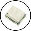 IMX-6
IMX-6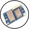 IMX-6-GNSS
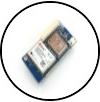 IMX-6-RTK
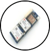 IMX-6-DUAL

