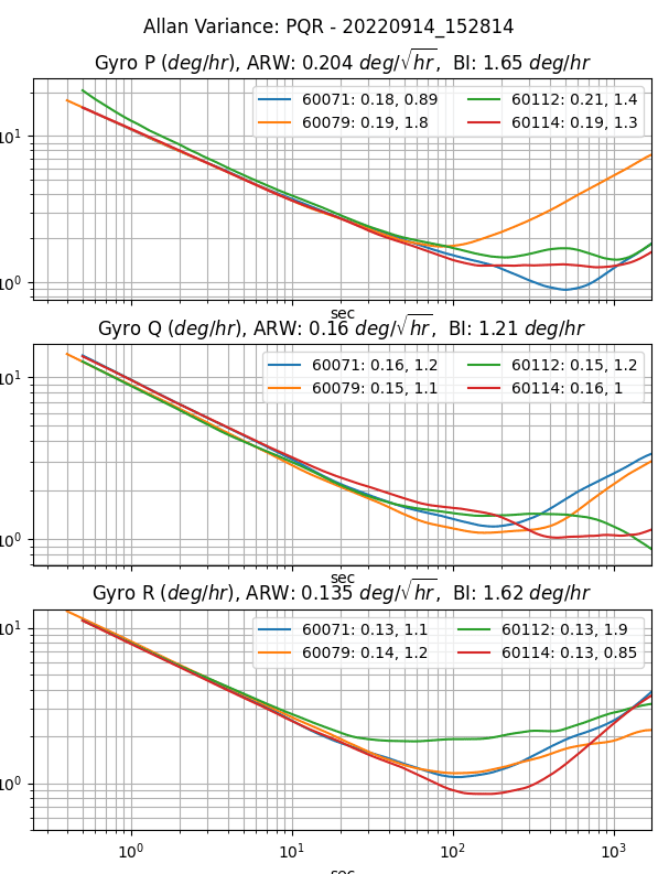
An Inertial Measurement Unit (IMU) is industry qualified as “Tactical Grade” when the In Run Bias Stability (IRBS) of the gyroscopes is between 0.5 deg/hour and 5 deg/hour. The IRBS represents the IMU stability during benign conditions (i.e. ideal integration time, stable temperature, and no inertial motion).
IEEE-STD-952-1997 defines IRBS as the minima on the Allan Variance curve. The following plots identify the Allan Variance representation of four IMX-5 tactical grade IMUs (serial numbers 60071, 60079, 60112, and 60114).
IMX means inertial measurement device with extensible capabilities. IMX is a derivative of the acronym IMU. Our flagship product was named the uINS which means miniature Inertial Navigation System (INS). This name has helped others to recognize the inertial navigation functionality. However, we felt that a more generic name would better cover all of the various functionality and capabilities contained in the IMX
Tactical grade Inertial Measurement Unit (IMU)
Barometer and magnetometer sensors
Vertical Reference Unit (VRU)
Attitude Heading Reference System (AHRS)
GNSS aided Inertial Navigation System (GNSS-INS or GPS-INS)
RTK-GNSS aided INS
Dual-GNSS (GPS compassing) aided INS
Ground vehicle Dead Reckoning system
Inertial Navigation is a technique of estimating position, velocity, and orientation (roll, pitch, heading) by integrating IMU inertial motion data from gyros and accelerometers to continuously calculate the dead reckoning position. The inertial sensors are supplemented with other sensors such as GPS, altimeter, and magnetometer. Inertial Navigation is commonly used on moving vehicles such as mobile robots, ships, aircraft, submarines, guided missiles, and spacecraft.
- Dead Reckoning – An Inertial Navigation System (INS) integrates the IMU data to “dead reckon” or estimate position and velocity between GPS updates and during GPS outage. The accuracy in denied GPS areas highly depends on the precision of the sensors and kinematic assumptions about the vehicle. The IMX from Inertial Sense can dead reckon in free floating application (like in a drone) for 15 seconds with <2m accuracy or in a ground vehicle for 105 seconds with <2m accuracy.
- Higher Data Rates – Typical GPS receivers data rates vary from 1Hz to 20Hz, whereas INS systems like the IMX can output at data rates up to 1KHz.
- Signal Conditioning – An INS filters out noise in the GPS data and provides a smoother, more consistent state position and velocity.
- Orientation Data – An INS is capable of observing the orientation (roll, pitch, and heading) of the system regardless of the motion or direction of travel. This is because of how an INS fuses inertial data with GPS data. A GPS with one antenna can measure direction of travel (ground track heading) but cannot estimate vehicle roll, pitch, or heading.
Inertial Measurement Unit → Attitude Heading Reference System → Inertial Navigation System
I have my own GPS system and just need raw motion data, which sensor is for me?
If you have your own filters in place and need raw data for measuring motion, then the IMU is the best option. The IMU provides raw, calibrated data for temperature, 3D acceleration (accelerometer), 3D magnetic field (magnetometer), and 3D rate of turn.
Which sensor will also provide attitude (roll/pitch/yaw) and heading data?
The AHRS sensor has all the capabilities of the IMU plus data on roll, pitch, and yaw. This sensor uses algorithms to fuse raw data from the IMU with the Earth’s gravity to provide orientation and is perfect for a robotic arm or indoor floor cleaner.
I need geographic positional data. Which sensor contains a GPS?
If the AHRS doesn’t get you what you need, packaging this with one or more GPS sensors will give you the geographic positional data you need. Like the AHRS, your sensor or should provide some sort of “sensor fusion” by combining all the data from each of these sensors to give a more accurate and holistic view of your rover’s state.
What do I need to get started?
We recommend beginning with some sort of Development Kit. Ours comes with all of the necessary components to simplify testing and integration: the sensor you selected, the needed cable and antennas for connectivity, the firmware & software, and 3-5 hrs of complementary engineering support from a team of Inertial Sense engineers.
Additionally, Inertial Sense provides customers with a custom datalogger, called the EvalTool. An easy to use data logging software to test and troubleshoot your new sensor is essential to your sensor integration experience.
I need GPS data, what do I need to purchase?
For full GPS capabilities, one of our INS kits is the best option. Each of our IMU and AHRS kits contains an antenna, however, the GPS integration is limited and intended for simple time-stamping only.
Can the INS estimate position without GPS?
No. GPS is required to provide initial position estimation and to aid in IMU bias estimation. The INS can dead reckon (estimate position without GPS) for brief periods of time. However, the quality of dead reckoning is a function of IMU bias estimation, which improves while the GPS is aiding the INS.
How long can the INS remain accurate after losing GPS?
The INS inertial navigation integrates the IMU data to dead reckoning position and velocity estimation between GPS updates and for a short period of time during GPS outages. Dead reckoning is disabled after 10 seconds of GPS outage in order to constrain position and velocity drift. The amount of position drift during dead reckoning can vary based on several factors, including system runtime, motion experienced, and bias stability.
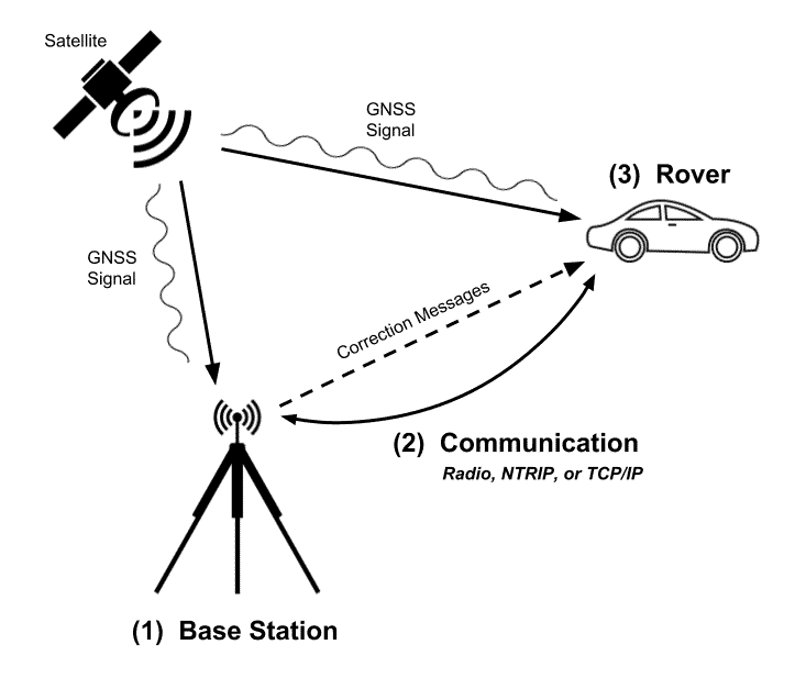
What is RTK and how does it work?
RTK or Real-Time Kinematic, is a technique used to increase the accuracy of GPS signals. It uses a fixed base station that wirelessly sends out corrections to a moving receiver. By utilizing these corrections, the GPS can fix the position of the antenna within 1-3CM.
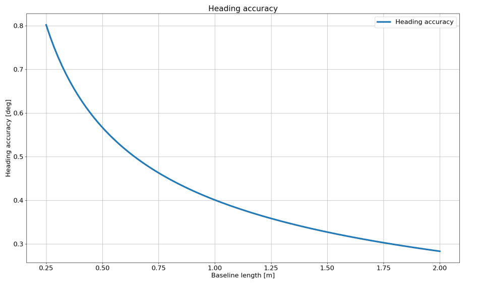
What is Dual Compassing?
This configuration consists of two GPS antennas placed on a fixed baseline to provide accurate and reliable GPS-based heading instead of solely depending on the Magnetometer and Gyros.
Does the INS use Dual Compassing and RTK simultaneously?
Currently, our Dual Compassing INS can perform either feature by toggling between RTK and Dual Compassing within the firmware. Our roadmap reflects our intention to create simultaneous use of RTK and Dual Compassing within the coming year.
What is the IP rating of the Rugged?
IP40 (no liquid protection)
Are your units weatherproof?
Based on our IP rating of 40, our units are not considered waterproof. Although we have an aluminum enclosure, you will need to take additional measures if you need this unit to be considered weatherproof.
Can the INS operate underwater?
The INS can only dead reckon for short periods of time and in general requires GPS to provide position and velocity data. The GPS antenna must be above the water surface in order for the GPS to function properly. It is ideal that the GPS antenna be fixed relative to the INS (IMU) module in order to maintain precision when moving faster than 2 m/s or 0.8 m/s^2. However, the GPS antenna may be tethered above the INS, where the GPS antenna is floating on the water surface and the INS is below the water surface. System position will reflect the GPS antenna position and attitude (roll, pitch, heading) will reflect the INS module orientation.
How do I know if I need “Rugged?”
If you’re using it for autopilot, mining, powerlines or other outdoor or harsh applications, we are probably going to suggest you go rugged. Our rugged form factor provides an aluminum casing to protect your sensor in harsh applications.
Do you support PPK?
While we can provide you with the raw data necessary to do your own Post-Processing Kinematic (PPK), we currently do not offer PPK software. Please let us know if this is an enhancement you’d like to see in our roadmap.
Do any of your units support odometry input?
This feature is internally supported and can be made available based on request and our discretion.
Do you integrate with Pixhawk?
We provide the raw data for Pixhawk but do not integrate directly. Only GPS data can be passed to Pixhawk. The IMX provides standard ASCII NMEA GPS messages.
How does vibration affect navigation accuracy?
The INS accuracy may degrade in the presence of mechanical vibrations that exceed 3g of acceleration. Empirical data shows degradation at approximately 100 – 150 Hz. Adding vibration isolation to the mount may be necessary to reduce the vibrations seen by the product and to improve accuracy.
GNSS and INS are terms to describe navigation sensors for vehicles, robots, etc. GNSS specifically refers to the full Global Navigation Satellite System which is compromised of several satellite systems providing global coordinates. INS refers to Inertial Navigation Systems which is more generally any system that gives any of attitude, heading, velocity, acceleration, and other location and orientation related data.
A GNSS INS sensor is an inertial sensor that receives GNSS (or GPS) information to provide more accurate location and orientation data.
