What Is RTK and Why Do I Need It?
In this ever-developing world of technology, refining and improving the concept of “ultimate precision” sits proudly at the top of the list for many innovators all over the world. Even a few years back, the Global Navigation Satellite System could determine the position with an accuracy of 2-4 meters. With RTK (Real-Time Kinetic) GPS, position accuracy is now 2-4 cm. While the difference between a few meters and a few centimeters can still be measured by a measuring tape, the difference that it makes for technological advancements in our time is astronomical.
As automation has been adopted by the public as a means for making life easier and technology more manageable, users have also become substantially more dependent on it. Before RTK was introduced, we had to manually pinpoint our location, but now RTK does the job for us.
GNSS receivers had to measure the time taken for a signal to reach the receiver from the satellite by traveling through the ionosphere and atmosphere. These initial barriers slowed the signal. Which is why GNSS had low accuracy.
How old is RTK GPS?
RTK GPS has been around for a long time, as long as the GNSS. It has only been a few years since RTK was introduced to the public but in Bluetooth signal.
Before Bluetooth RTK was introduced, RTK was only available to the construction industry, licensed land surveyors. Its extortionate price made it impossible for the engineering and environmental firms, as well the government land management group to afford them.
With the arrival of Bluetooth RTK, its price dropped significantly which eventually made it affordable for the rest of the industries. Now we see RTK GPS technology in drones, cars, planes, boats and more.
How RTK works?
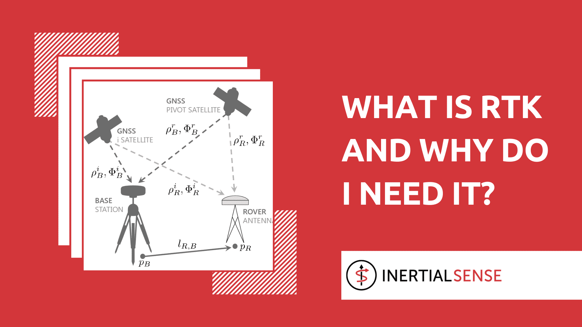
Unlike GNSS, RTK has two receivers. One remains static while the other moves around freely. These two receivers are called the base station and rover respectively.
The job of the former is to stay fixed and send corrected data to the latter. The rover than calculates the distance using the data and produces a centimeter-accurate position. One base can be connected to a number of rovers on if the base’s output setting matches the rover’s input settings.
Understanding the working process of RTK can be intimidating. In layman’s terms, the basic function of RTK is to remove errors and reduce inaccuracies using a base station and a rover.
RTK explained
RTK GPS is dependent on different transmissions and corrections methods that can be used for determining locations. The corrections to improve the location accuracy are either received from a dedicated base station or from the RTK base station.
The most efficient (and most cost-effective) way to utilize an RTK receiver is through real-time corrections provided by a base station. These base stations typically are purchased with the RTK receiver but there are other private and governmental organizations that provide pay-for-service access to permanent base stations throughout cities or localities.
Bluetooth RTK machines have made it easy for the biologist, engineers, geologists and students to acquire centimeter precision location data.
Role of RTK in Different Industries
RTK for Drones
The primary benefit of RTK is its pinpoint location accuracy capability. RTK brings immense benefits for the pilots as they can now get the pinpoint location of the aircraft that allows exact hovering in all conditions.
Aircraft that feature RTK allows pilots to fly close to objects and operate in small spaces. RTK also provides the pilot with meticulous data even when the aircraft is moving.
Apart from location accuracy, RTK GPS also shields against electromagnetic field and radio frequency interference. This type of interference typically occurs when aircraft fly close to radio towers, power lines, and metal edifices. EMF and RF frequency can disrupt your aircraft’s flight by forcing it to enter ATTI mode which will eventually lead to either drone crash or flyaway.
The aforementioned benefits make RTK an ideal choice for enterprise pilots for industrial applications.
Apart from protection, RTK is also helpful in geotagging of the data captured by the aircraft that includes both video and images.
RTK for Telecommunication Inspection
Drones powered with RTK GPS have restructured the telecommunication industry. It has made inspections easier and thorough. Before RTK, telecommunication inspections were a much more rigorous and time-consuming process. Now, with the RTK powered drone, it is easier to precisely locate faults in mobile towers without interfering with the aircraft’s signal and without putting workers at risk.
With stable hovering features, images can also be taken if required even when the aircraft is moving.
RTK in Powerline Inspection
Apart from the Telecommunication industry, RTK has been massively beneficial in Powerline inspection. It has promoted safety along with productivity.
RTK can embrace electromagnetic interference without causing any interruption in your drone’s flight.
RTK in Offshore Rig Inspection
Regular inspection of the offshore rig is essential for ensuring worker’s safety. Carrying out inspection using RTK powered drones will now provide accurate information but also save time.
RTK for Surveying and Mapping
RTK is immensely beneficial for improving vertical accuracy while surveying stockpile. Using a combination of RTK and waypoints, accuracy in mapping and surveying can also be improved dramatically. Waypoints also create autonomous flight on pre-selected courses.
RTK ensures that your drone remains on course both vertically and horizontally.
RTK in Cinematography
The usage of drones in cinematography is not something new. They have been used profoundly since drones started featuring video-taking capabilities. The usage of drones in cinematography has seen rapid growth in the past few years with the introduction of RTK.
With RTK GPS, pilots can now maneuver back to the exact position for multiple takes. Accurate hovering also allows stable shots.
You Need RTK
RTK can be termed as the future of mapping and surveying. It ensures improved safety, reduced cost, and higher accuracy that makes UAV mapping way more precise than ever. If you’d like to learn more about RTK, Contact Us today and speak with an RTK expert. Together, we’ll discuss the best fit for your robotics build as we discuss your current sensors and base station sensors. Ready to shop? We’ve got what you need – Click here to view all of our current RTK offerings.